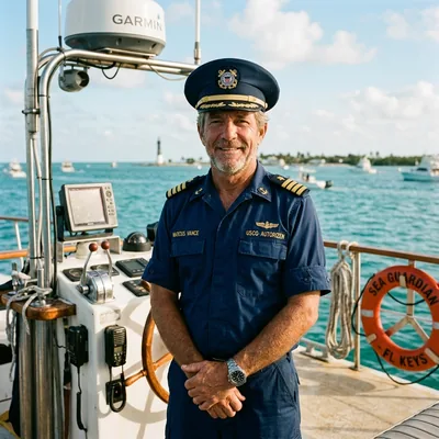
Key Largo is the premier northern gateway to the Florida Keys (Mile Marker 107.5 to 90.5), housing the first undersea park in the United States, living coral barrier reefs, world-class diving sanctuaries, and the historic Overseas Highway transit corridor connecting mainland Florida to Key West.
Nautical Navigation Telemetry
Mile Marker & Reef Condition Calculator
Station MLRF1 Calibrated
Departure Origin (Overseas Highway)
Key Largo Destination Landmark Presets
Target Sanctuary Reef Site
Overseas Highway Traffic Flow:
MARITIME NAVIGATION SCORECARD
Shareable Florida Keys Transit Card
Copied!
Driving Distance23.5Miles (US-1)
Estimated Duration31Minutes
Reef Bathymetry10–40Feet Depth
Reef Mooring32Public Buoys
Molasses Reef SPA: Living barrier reef tract with high coral diversity and historic lighthouse beacon.NOAA Station MLRF1
Trip Itinerary Scratchpad
No itinerary stops saved yet. Click "+ Save Current Leg" to build your offline Florida Keys route.
Captain Marcus Vance
USCG Master 50-Ton Near Coastal
Lead Marine Navigation Specialist • 18 Years Upper Keys Maritime Experience
Captain Vance oversees navigational modeling, reef bathymetry data from NOAA Station MLRF1, and Overseas Highway corridor transit benchmarks for KeyLargo.online. Independent mariner verification ensures all tidal formulas and mile marker coordinates reflect physical waterway reality.
What is Key Largo and Where Does the Gateway Begin?
Key Largo functions as the northern strategic hub of the Monroe County maritime transportation network, connecting mainland Florida at Florida City (Mile Marker 126 via the 18-Mile Stretch of US-1) to the central Keys archipelago. Navigating this barrier island corridor requires understanding both terrestrial highway logistics and federal marine sanctuary boundaries established under the Florida Keys National Marine Sanctuary (FKNMS) and the Florida Department of Environmental Protection (FDEP).
Addressing in Key Largo relies strictly on physical Mile Marker (MM) coordinates along US-1, running from MM 107.5 at the northern end down to MM 90.5 at Tavernier Creek Bridge. Every property is designated as either "Bayside" (facing northwest toward Blackwater Sound, Buttonwood Sound, and Florida Bay) or "Oceanside" (facing southeast toward the Hawk Channel, living coral barrier reefs, and the Atlantic Straits of Florida).
Environmental management along the Key Largo coastline is governed by federal Sanctuary Preservation Areas (SPAs), ecological reserves, and Monroe County idle-speed canals. Within SPAs—including Key Largo Dry Rocks, Molasses Reef, and French Reef—anchoring directly on living coral is strictly prohibited by federal maritime law. Boaters must utilize white public mooring buoys maintained by sanctuary staff, and all consumptive harvesting, spearfishing, and marine collection are completely prohibited to maintain ecological balance.
Data Freshness:Synced with NOAA FKNMS / Station MLRF1•Updated TodayDaily Hydrographic Calibration
USCG & Sanctuary Standards Verified
Interactive Key Largo Mile Marker & Transit Condition Workbench
Precision nautical calculations are critical when navigating shallow Upper Keys waters, where tidal flux through passes like Tavernier Creek and Adams Cut creates significant current variations. When navigating offshore from Key Largo marinas to outer bank barrier reefs, captains must calculate effective vessel velocity by factoring in prevailing tidal current vectors and Gulf Stream edge boundary effects.
Nautical Transit Time & Tidal Current Velocity Equation
t = d / (v_vessel ± v_current)
Notation:Transit Time (hours) = Distance (NM) ÷ (Vessel Speed ± Current Velocity)
Variable Definition & Units
d
Nautical Distance[nautical miles (NM)]
Direct GPS distance from marina departure point to offshore reef mooring.
v_vessel
Cruising Velocity[knots (kts)]
Vessel throttle speed through water under nominal engine RPM.
v_current
Tidal Current[knots (kts)]
Florida Current / Gulf Stream velocity vector (+ for following, - for opposing).
Calibrated Example:
A 6.5 NM passage to Molasses Reef at 18 knots cruising speed against a 2.5-knot opposing Hawk Channel tide requires 25.2 minutes transit time (6.5 ÷ 15.5 kts).
Vessel draft management is equally paramount in Key Largo. Most natural bayside access channels maintain 4.0 to 5.5 feet of draft clearance at mean lower low water (MLLW), while the main Hawk Channel inside the barrier reef tract carries 10 to 14 feet of depth. Skippers operating center consoles and sailing catamarans must cross-reference real-time tide telemetry from NOAA National Ocean Service tide stations before entering shallow sound passes.
CalibratedReef Distance Benchmark: 5.8 to 7.2 NM from Shore to Barrier Outer WallPASS • Station MLRF1
Key Largo Protected Marine Sanctuaries & Dive Site Depth Matrix
The Overseas Highway corridor through Key Largo encompasses four distinct operational zones, each characterized by localized speed limits, public boat ramps, marina facilities, and waterway access points. The table below details statutory transit dimensions across the 17-mile island span.
Mile Marker Sector
Geographic Span
Key Nautical & Transit Facilities
North Key Largo Gateway
MM 107.5 – MM 104.0
Gilbert's Resort, Jewfish Creek Bridge, Lake Surprise, Card Sound connector.
Pennekamp & Central Hub
MM 103.5 – MM 99.0
John Pennekamp State Park entrance (MM 102.5), Key Largo Harbor Marina, Adams Cut waterway.
Rock Harbor & Bayside
MM 98.0 – MM 94.0
Baker's Cay Resort (MM 97.0), Florida Bay sunset docks, Harry Harris Park & boat ramp (MM 92.5).
Tavernier Creek Boundary
MM 93.0 – MM 90.5
Tavernier Bridge, deep-water marina basin, direct bayside-to-oceanside pass into Islamorada.
2,900 Sq NMProtected SanctuaryContinental North America's only living barrier reef.
25 FeetChrist of the Abyss DepthFamous underwater bronze sculpture at Dry Rocks.
45–55 mphOverseas Highway SpeedStrict radar enforcement in residential and town zones.
Federal StandardFKNMS 15 CFR Part 922 Marine Sanctuary Directives
Ref: NOAA-NOS-2019-0094
Statutory Monroe County Transit Regulations & Mooring Protocols
Vessel operations within the Florida Keys archipelago are governed jointly by Monroe County ordinances, the Florida Fish and Wildlife Conservation Commission (FWC), and NOAA federal sanctuary regulations. Understanding these rules is essential to avoiding severe statutory fines and protecting delicate marine habitats.
Sanctuary Ecological Standard:Zero Coral Grounding / Mandatory Mooring Buoy Use
Three primary vessel compliance standards apply throughout Key Largo:
Zone Regulation
Idle Speed / No Wake
Mandatory within 300 feet of residential shorelines, marinas, and fuel docks. Vessels must proceed at minimum speed to maintain steerage.
FKNMS Protection
5 Designated SPAs
Carysfort, The Elbow, Dry Rocks, Grecian Rocks, and French Reef. Anchoring on living coral is illegal; mandatory NOAA mooring buoy usage.
Wildlife Habitat
Manatee Corridors
Bayside mangrove creeks enforce strict seasonal and year-round idle speed restrictions to protect congregating West Indian manatees.
Sanctuary Status5 Major SPAsDesignated no-take coral preservation zones.
Speed Zone300 FeetIdle Speed / No Wake buffer from shorelines.
Chart DatumNOAA 11462Official hydrographic chart for Upper Keys waters.
Frequently Asked Questions About Visiting Key Largo
What is Key Largo and Where Does the Upper Keys Gateway Begin?
Key Largo is the longest island in the Florida Keys archipelago, commencing at Mile Marker 107.5 just south of Florida City mainland and extending to Mile Marker 90.5 at Tavernier Creek. It serves as the primary gateway to the Florida Keys National Marine Sanctuary.
How Does Mile Marker (MM) Addressing Work Along the Overseas Highway?
The Overseas Highway uses green Mile Marker signs descending from MM 126 in Florida City down to MM 0 in Key West. All marinas, reef access points, and lodging in Key Largo are identified by decimal Mile Markers (MM 107.5 to MM 90.5), with Oceanside (Atlantic) and Bayside (Florida Bay) orientations.
Where Are the Best Coral Reefs and Snorkeling Sites in Key Largo?
Key Largo Dry Rocks (home to the Christ of the Abyss at 25 ft depth), Molasses Reef (famed for spur-and-groove coral towers and NOAA Station MLRF1), French Reef, and Grecian Rocks provide world-class snorkeling and scuba within John Pennekamp Coral Reef State Park.
What Are the Primary Boating Regulations and Speed Zones in Key Largo Waters?
Monroe County and FKNMS enforce strict Idle Speed / No Wake zones within 300 feet of residential shorelines and marinas. In Sanctuary Preservation Areas (SPAs), anchoring on living coral is illegal; vessels must tie off to white public NOAA mooring buoys.
🍪
Privacy & Cookie Preferences
We use privacy-first analytics to understand transit calculator usage and improve Florida Keys navigation tools. We respect your privacy rights under GDPR and ePrivacy directives.
Privacy Policy